LOCATION:
On the edge of Manitou Springs, next to the Cog Railway.
THE INCLINE
TRIP TIME:
1-3 hours
DISTANCE:
2 miles- Incline up and down
5 miles- w/ Barr Trail
ELEVATION:
Start- 6,600 ft
End- 8,600 ft
RATING:
Scenery- 8
Crowds- 9 (10 is packed)
Difficulty- 7
My Overall- 8
WHAT TO BRING:
-Water bottle
-Running shoes/ light hikers
-You might want a dry layer for the way down.


THE INCLINE

THE HIKE:
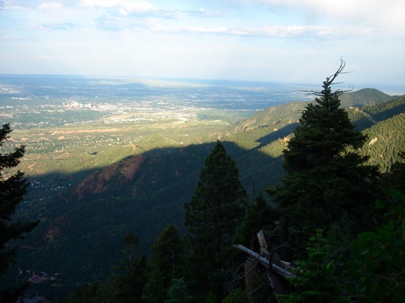
This place has its own community. Whether it’s your first time or hundredth, you’re feeling the same pain as everyone else. And you’re all doing it by choice. Strangers see you in a weird survival mode (that’s another way of saying you look terrible). But you see them like that too, so no need to feel bad. When you get to the top, you’ve all earned and share the same view.
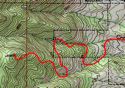
ROUTES:
Mix and match however you want. Take the incline all the way to the top, or bail left before the false summit (there’s a shortcut to Barr Trail). If you conquer the beast and didn’t get enough, go right back down it, (this is the fastest way, but it’ll piss-off your knees) or hop onto Barr Trail. Some run this part, but there’s no shame in taking your time.
GOOD TO KNOW:
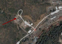
-Take the little trail at the northwest corner of the parking lot to get to the Incline. It’s unmarked and confusing on your first time.
-If you’ve never climbed the incline, pace yourself. The middle section is full of uneven and painfully tall steps. Don’t think you can run the thing. Also, there’s a false summit; meaning what looks like the top, isn’t. Fortunately, the true summit is friendlier.
-You’ll get faster every time you climb it... for the most part. And it beats the hell out of a stair-stepper. Just keep going and try to shut your mind off.
-Don’t wear jeans. The hike is already uncomfortable, and jeans will make it worse. Why do that to yourself?


RESOURCES:


CLICK FOR THE INCLINE ALBUM