LOCATION:
North West side of town -off Woodmen Road
Blodgett Water Tower
TRIP TIME:
30 min - 1 hr
DISTANCE:
1 mile to the water tower
2 miles roundtrip
ELEVATION:
Start- 7,050 ft
End- 7,400 ft
RATING:
Scenery- 6
Crowds- 4 (10 is packed)
Difficulty- 2
My Overall- 5
WHAT TO BRING:
-Water bottle (optional)
-Running shoes/ light hikers
-Your dog?


BLODGETT


RESOURCES:


THE HIKE:
Blodgett Open Space is a North-side treasure. It has easy trails loaded with great views. And you’ll probably run into some wildlife while you’re out there.
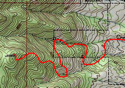
THE ROUTE:
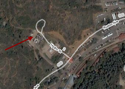
The parking lot sits right at the foot of Blodgett Peak. Take Woodmen Road as far West as it goes and you’ll be there.
To hike to the water tower, get on the dirt road at the end of the parking lot. It steadily and slowly winds up the mountain.
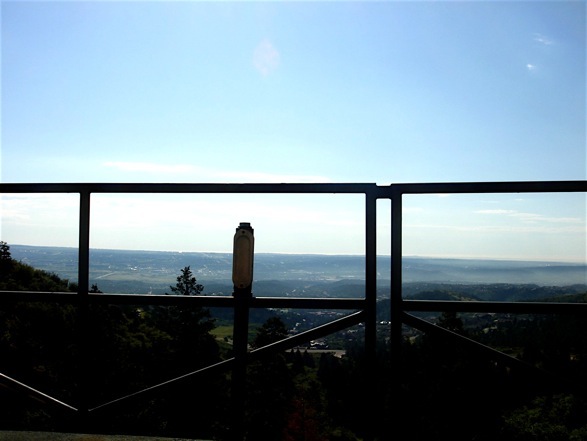
After 1 mile, you’ll come up on the water tower. Scurry up the hill to get on top. The view of the city is big and humbling, and it hardly takes any work to get there. Soak it in or start the quick trip down.
If you want a little more adventure, try another trail. As long as you feel yourself walking downhill, you ought to get to the car at some point.
GOOD TO KNOW:
-If you’re an extreme hiker, this one isn’t for you.
- Named after a family of early settlers, Blodgett Peak stands 9,423 ft above sea level. Over 100 years ago it was known as Cedar Mountain. And Woodmen Valley just below it, was called Cedar Mountain Valley. That might be good to know.
-At some point, you’ll probably hear a little rustling in the bushes. Most the time it’s a squirrel, bird, or maybe even a deer. But there is a small chance it’s a Black Bear or Cougar. No worries though, just don’t pick a fight.
CLICK FOR BLODGETT WATER TOWER ALBUM